Floodplains: Key to Ecosystems and Flood Management
The City of Hendersonville took initiative to host a Floodplain Workshop for City Council, County Elected officials, stakeholders, and community members. It was well attended, and very informative. Mike Huffman, City of Hendersonville Stormwater Director gave a thorough overview of the city’s current ordinances.
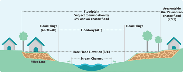
Floodplain and Floodway 101
Floodplains are essential ecosystems, providing habitat for wildlife, maintaining water quality, and supporting agriculture. However, when natural water flows are disrupted by urban development or climate change, these areas become vulnerable to more frequent and severe flooding events.
Floodplain management balances development and conservation, ensuring that while communities grow, they remain resilient to flood risks. Effective floodplain management involves zoning regulations, land use planning, and floodplain mapping to guide appropriate development and reduce flood damage.
At the workshop, local and state floodplain administrators explained that while floodplains may have varying flood risks, floodways are particularly important in maintaining flood control. A floodway is typically the area that experiences the most intense flow during floods, so any disruption here can worsen flooding for surrounding regions.
Flood Plain Maps
New Floodplain maps come out every 5-8 years. For Buncombe, Henderson, Madison, and Transylvania Counties, the new flood maps will be out in Spring of 2025, these do not include data from Helene. However, there is also a LIDAR mapping system (3D laser) that will come out for the BABRM counties represented (Buncombe, Henderson, Madison, and Transylvania). The LIDAR data will be overlaid on top of the standard maps, will include Helene data, and be available late fall of 2025!
Conversations will move forward with the Floodplain areas, Floodplain ordinance and regulatory updates will continue this year.
City of HVL Floodplain Workshop
Seen from left to right, Councilwoman Lowrance, Councilwoman Simpson, Mayor Pro-Tem Hensley, and Councilwoman Baxter.
Simplified Summary
Floodplains are important for wildlife and water quality but can flood more often with climate change. New flood maps are coming in 2025 to help keep communities safe.
